Rock art was created by artisan shaman (men and women) who were observers of nature and the universe. They were people who wanted to relate their observations, religious beliefs and experiences, or portray images of themselves or mythological figures. They used rock art to assist in a hunt, or to make a record of the seasonal passage of the sun or a star. Shamanistic symbolism is present throughout and represents techniques of a particular elite, who were able to communicate with the supernatural through visions created by fasting or ingesting hallucinogenic plants. They were able through animal spirit helpers to transform themselves, and such helpers are commonly depicted in rock art of the Southwest. As artisan-shaman probably created the majority of the rock art, sites where it occurs likely served some manner of religious center or spiritual focal point.
Defining temporal and possible cultural boundaries through rock art images is an on-going research process. “Repeated motifs can be identified and traced through time and space, which in turn may shed light on the dynamic histories of human populations, patterns of their migrations and interactions, and even continuities to the present indigenous societies”. Preservation of the images is key to the future research. Technological advances in photography and new computer programs are aiding in this effort.
Methodology for rock art documentation has significantly improved in recent years, during which cutting edge technologies have contributed to achieving more accurate representation of rockart images. Digital single lens cameras (DSLR) and improved image processing software greatly enhances the preservation and interpretation of rock art images. The plug-in DStretch is an important tool in that process, allowing the identification of very poorly conserved pigments and an easier distinction of overlap in motifs. Photo editing allows for the removal of graffiti, especially when used in conjunction with Dstretch, which can produce multiple layers from which to work.
Petroglyphs and pictographs are continually at risk from natural and man-made causes. DARG is developing an on-going rock art recording and database project to create "preservation quality" documentation for these irrereplaceable cultural resources. We continue to add to this database as they are encountered in the field.
Ongoing Research Projects
Archaeological Reassessment of Rock Art in Canyon Pintado National Historic District: Phase I
This project begins a major preservation, research, and public archaeology initiative for rock art resources in Canyon Pintado National Historic District (5RB.984) located south of Rangely, Colorado in Rio Blanco County. A team of archaeologists and technical specialists organized by Dominquez Archaeological Research Group (DARG) will revisit and intensively record twelve high-value rock art sites in the East Four Mile Draw site complex using advanced, high-resolution digital imaging and computational image processing techniques. Project data will be organized for review, assessment, and curation by tribal, agency, and professional research partners; and will establish baseline recording protocols for future phases of the project. Selected digital products will be shared with public archaeology and education partners. The project will leverage long-term collaborative relationships among professional, tribal and preservation partners; and will encourage newly formed coalitions promoting public archaeology, site stewardship, historic preservation and heritage tourism in an under-served area of the state.
Archaeological Assessment of the Caps Spring Rock Art Sites (5DT2156 and 5DT2157), Delta County, Colorado. Prepared by Carl Conner (Principal Investigator), James D. Keyser (Rock Art Specialist), Holly Shelton (Archaeologist), Masha Conner and Thuong Pham (Graphic Artists/Photographers), Nicole Inman (Administrative Staff), and Barbara Davenport (Editor) for History Colorado State Historical Fund, February 2019
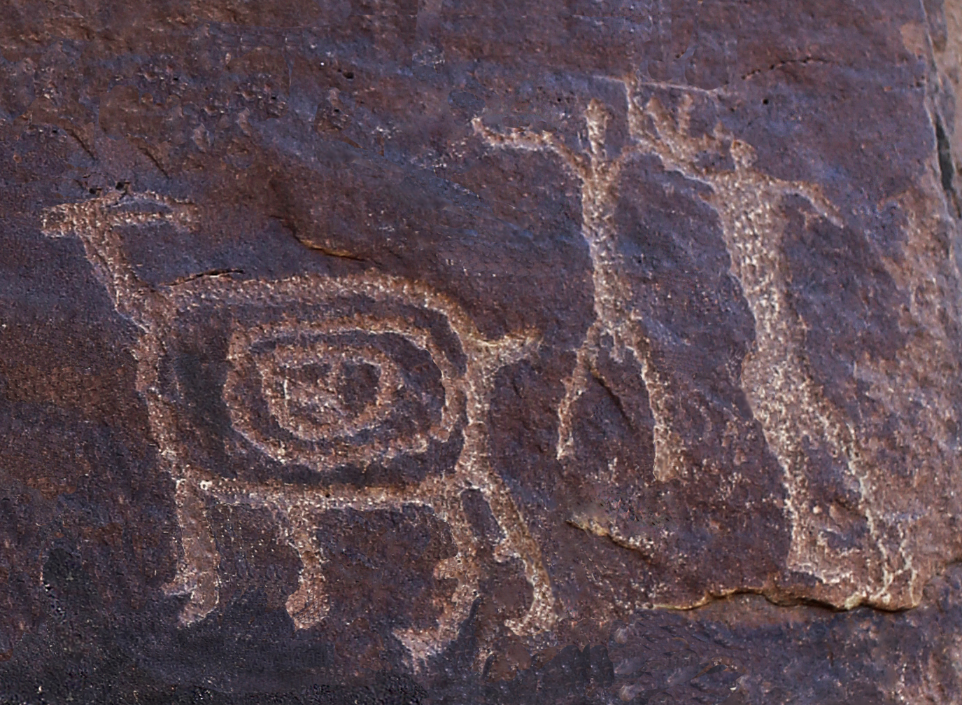
This is a History Colorado State Historical Fund grant (2018-AS-002) project undertaken by Dominquez Archaeological Research Group (DARG) for the purpose of conducting documentation of two rock art sites (5DT2156 and 5DT2157) in Escalante Canyon, Colorado. Site 5DT2156 was previously recorded in 1974 as site 5MN860 – incorrectly placed in Montrose County. Originally described as containing a “snake” petroglyph, its location was corrected and it was fully recorded. Newly documented 5DT2157 has stylized images of bear and mountain lion tracks, bison, anthropomorphs, zoomorphs, and scratch art. One of the anthropomorphs is an image of an apparent pregnant female possibly giving birth, and another may represent an image of a Bear Shaman. These and other images on the panels at 5DT2157 have provided new insights into the rock writing themes of Native Americans of the region and the distribution of particular Tribal styles. This project has advanced DARG’s rock art research and documentation of design elements. At the bottom of this page, you can find a link to our gallery of rock art photos.
A report detailing the findings of this project is available here:
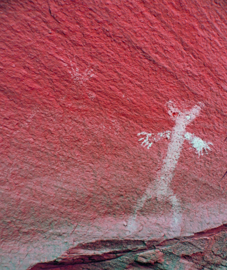
Identifying Cultural Landscapes: Archaeological Documentation and Analysis of Native American Rock Art along Proposed Prehistoric-to-Historic Trails in Mesa County, West Central Colorado. Prepared by Sally J. Cole, Rock Art Principal Investigator Ute Trails of Mesa County, Colorado for the History Colorado State Historical Fund (Project No. 2014-01-054), August 2016
The present research examines the nature and timing of Archaic, Formative (Fremont and Ancestral Pueblo), and historical Ute developments in west central Colorado through documentation and comparative analysis of rock art at 11 sample sites along the projected McDonald Creek and West Grand Mesa cultural trails or corridors (Dominquez Archaeological Research Group, Colorado State Historical Fund Project #2014-01-054). The subject petroglyphs and paintings are models for the range of reported styles in the region and patterns of distribution along the trails and in surrounding areas. Although broadly dated, the stylistic patterns point to routes for migration and settlements through time.
The proposed McDonald Creek trail crosses the Colorado River near the Utah line, connecting Glade Park and the Little Dolores River on the northern Uncompahgre Plateau to the Book Cliffs and Roan and Tavaputs plateaus, and beyond to the Uintah Basin. The West Grand Mesa trail would link Battlement Mesa and the upper Colorado River to the Gunnison River, gateway to the central and southern Uncompahgre Plateau and the Dolores and San Juan River drainages (Figure 1). Here, groups of prehistoric hunter-gatherers and Fremont and Ancestral Pueblo farmers marked distinctive landscapes; historical Ute (horse and rider) markers cross earlier boundaries. The rock art enhances knowledge of cultural dynamics and offers insights into past traditions and territories.
A report detailing the findings of this project is available here:
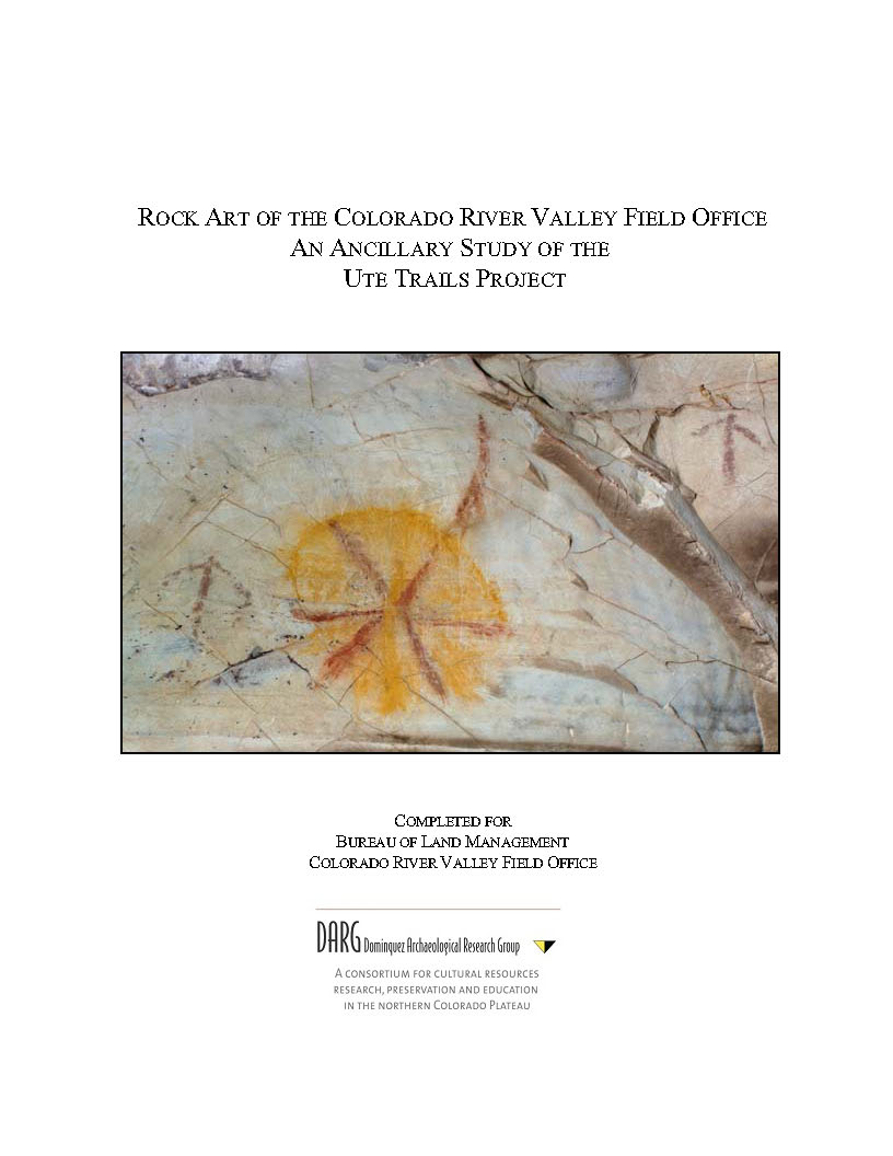
Rock Art of the Colorado River Valley Field Office: An Ancillary Study of the Ute Trails Project Completed for the Bureau of Land Management Colorado River Valley Field Office. Prepared by Carl E. Conner, Barbara Davenport, and Masha Conner, December 2016
Abstract: This project is ancillary to the Ute Trails Project, a research endeavor of Dominquez Archaeological Research Group (DARG). The purposes of the study were to revisit and digitally photograph previously recorded rock art panels and record any new panels or sites encountered during the revisits. This report describes the settings and stylistic associations of the rock art, and examines questions of cultural affiliation and regional relationships.
A report detailing the findings of this project is available here: A public presentation of the project can be found here:
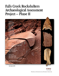
Falls Creek Rockshelters Archaeological Assessment Project - Phase II. Prepared by Karen R. Adams, Michael Berry, Mona Charles, Sally Cole, Phil R. Gieb, Carole L. Graham, Kristina Horton, Edward A. Jolie, Cerisa R. Reynolds, M. Steven Shackley, Laurie D. Webster, coordinated by Julie A. Coleman, San Juan National Forest Archaeologist and compiled by Carl E. Conner. Prepared for History Colorado State Historical Fund Grand Project 2012-01-038 and under San Juan National Forest Assistance Agreement, October 2014.
Abstract: Dominquez Archaeological Research Group, Inc. (DARG) and their associated researchers partnered with the San Juan National Forest and the State Historical Fund to conduct the “Reevaluation of Basketmaker II from the Falls Creek Rockshelters, Phase II” as outlined in the State Historical Fund grant (Project # 2012-01-038) This second phase of the Falls Creek Rockshelter project focused on the analyses of the non-NAGPRA Basketmaker II materials from the Falls Creek Rockshelter. The first phase of the project, which was completed in 2012, focused on the analysis of the NAGPRA related collections from the Falls Creek Rockshelters. With the completion of this project, we now have a more holistic understanding of the Basketmaker II occupation of Falls Creek. The Falls Creek Basketmaker II project has contributed very significant data regarding the earliest phase in the development of agricultural societies in the Southwest.
The results of Phase I and Phase II were shared with other professionals at the 2012 American Association of Physical Anthropologists Meeting, the 2013 Society of American Archaeology (SAA) annual meeting, and in 2014 with the Hopi Cultural Resource Advisory Task Team (CRATT).
To read a copy of the report,
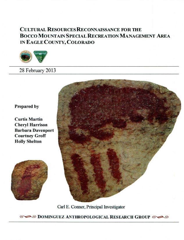
Cultural Resources Reconnaissance for the Bocco Mountain Special Recreation Management Area in Eagle County, Colorado. Prepared by Carl E. Conner, Principal Investigator, Curtis Martin, Cheryl Harrison, Barbara Davenport, Courtney Groff, and Holly Shelton for the Bureau of Land Management Colorado River Valley Field Office, Feb 2013
Site 5EA.1273 represents a sheltered camp documenting six distinct rock art panels all of which show the effects of time and weathering. Panel 1 has three elements: a bear zoomorph, three vertical lines, and an abstract element. Panel 2 is a small circle containing a vertical line and a separate vertical line. Panel 3 is another small circle containing a vertical line. Panel 4 contains four anthropomorphs, two zoomorphs, and two abstact figures that may represent atlatls. The anthropomorphs in this panel have headresses and necklaces similar to Fremont Culture rock art figures from West-central and Northwest Colorado. Panel 5 has a cross-hatched element. Panel 6 has a single anthropomorph. A seventh panel containing a blur of red paint is also present. An historic date of "Feb. 14.1934" is written on the wall with charcoal, the only evidence of Euro-american intrusion at the site. All the aboriginal figures are a deep red tone; two figures--one on the right side of Panel 4 and the single figure of Panel 6--are an even deeper tone of red and of a slightly different (possibly older) style. Anthropomorphic, zoomorphic, and abstract pictographic elements are present. Two abstract figures (Panel 4) may represent atlatls. Conner and Davenport (1997) note that this style of rock art is unusual in the central mountains of Colorado. Stylistically, it is comparative to Formative styles of west-central and northwest regions of the State. In particular, the anthropomorphs appear to have headdresses and necklaces similar to Uinta Fremont Classic Vernal Style elements (Figure 6).
This expression is estimated to date from approximately 550 to 1200 AD or later (Cole 2009). It is possible that the dominant (anthropomorphic) components of the style and associated ideas and practices were brought to the study area by a migration event that may coincide with a projected movement across the Cisco Desert at approximately 900–1000 AD (Bradley et al. 1986). In any case, the central figure also resembles the Classic Seiber Canyon Style from the northern Uncompahgre Plateau, and although distinctions exist between the Vernal and Sieber Canyon Styles, general and more specific similarities in subjects, forms, and themes are obvious. Differences are most notable with regard to the common use of paintings and the diversity of Classic Vernal Style anthropomorphs and the ways in which they are embellished (Conner et al. 2011:4-60).
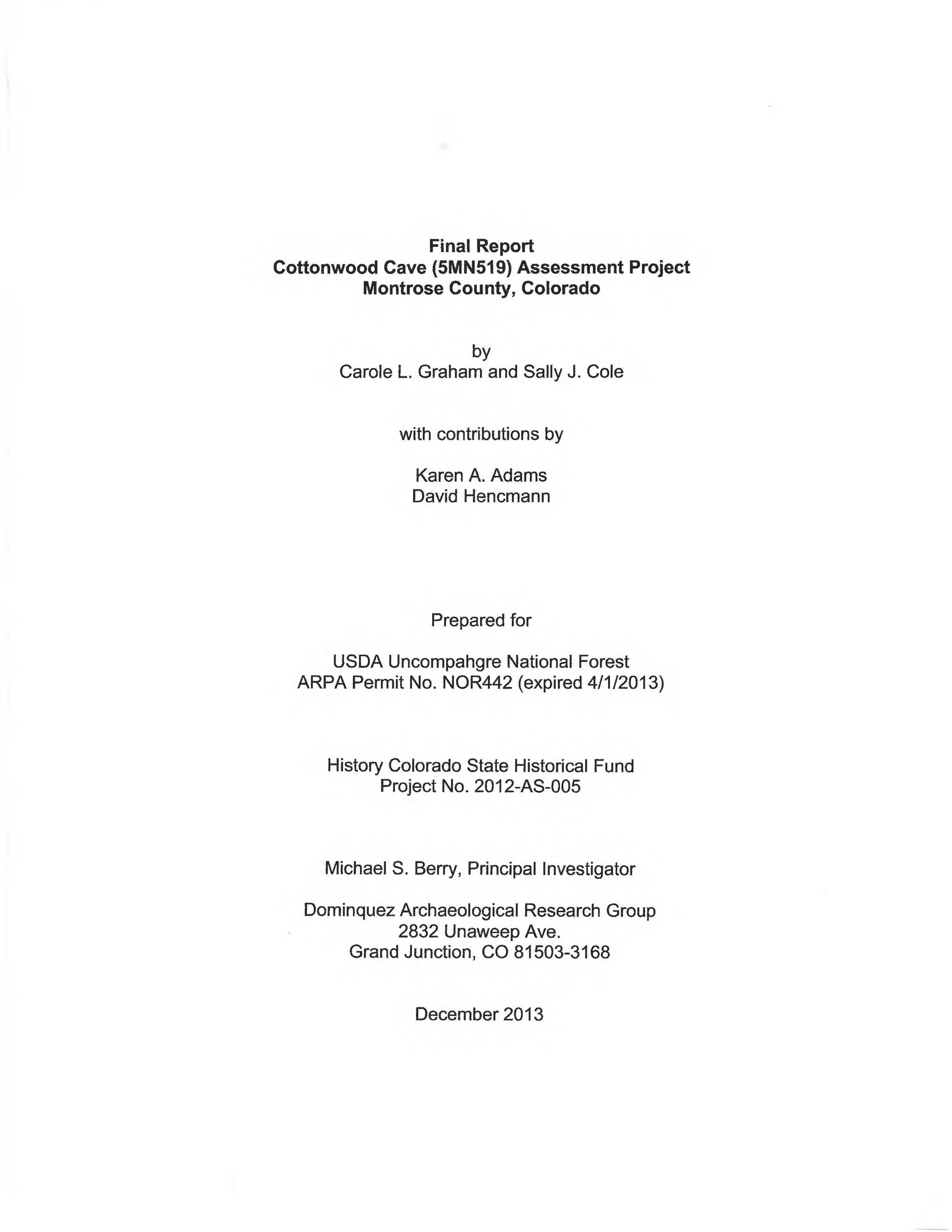
Cottonwood Cave (5MN519) Assessment Project. Montrose County, Colorado. Prepared by Carole L. Graham and Sally J. Cole. Contributions by Karen A. Adams and David Hencmann, Compiled by Michael S. Berry. Prepared for USDA Uncompahgre National Forest DARG, December 2013
Located along a tributary of the San Miguel River, in Montrose County, Colorado, Cottonwood Cave (5MN519) is a rockshelter with stratified deposits and rock art imagery. The Cottonwood Cave Assessment Project, supported by a grant from the History Colorado State Historical Fund, was developed in recognition not only of the site's potential to provide valuable data addressing the prehistoric transition to agriculture in western Colorado, as demonstrated in previous work by Hurst (1948) and Stiger and Larson (1992), but also of the site's vulnerability to vandalism and unauthorized excavation. The project involved the test excavation of two 1 m2 units, the mapping and re-recording of the site, including extensive rock art documentation, and AMS dating of plant and animal remains, including maize. Stylistically and chronometrically, the Cottonwood Cave rock art dates from Basketmaker II into Basketmaker Ill and possibly early Pueblo I times. Close relationships with San Juan Basketmaker 11 are evident, particularly with eastern populations at the Falls Creek Shelters (Adams et al. 2011 ), but also with rock art attributed to Basketmaker 11-111 populations in the Cedar Mesa and Moab, Utah areas to the west (Charles and Cole 2006; Cole 2009). Pueblo 11/111 use of the shelter is suggested by a probable celestial ceiling, presumably made by Pueblo II and possible Pueblo Ill residents of nearby Weimer Ranch and Cottonwood Pueblo sites (Gruebel et al. 2006; Hurst 1948).
The project report, edited for general release, is available here:
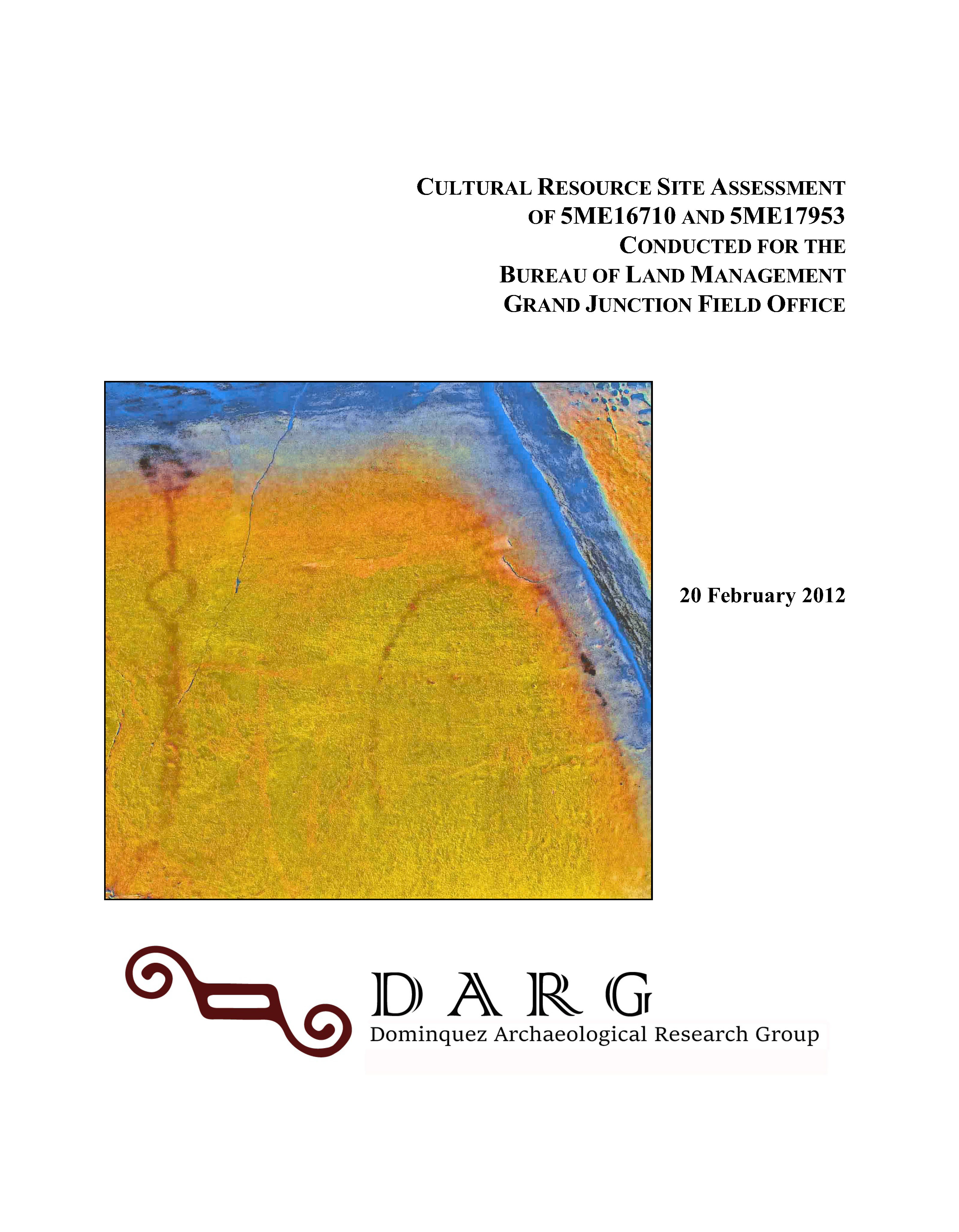
Cultural Resource Site Assessment of 5ME16710 and 5ME17953 Conducted for the Bureau of Land Management Grand Junction Field Office. Prepared for the Grand Junction Field Office Bureau of Land Management, Feb 2012
Dominguez Anthropological Research Group (DARG) working under ARPA Permit No. C-67009 completed a project for the site documentation of and data retrieval from two prehistoric sites (5ME16710 and 5ME17953) in Horseshoe Canyon, Mesa County, Colorado. Fieldwork was carried out on various days between October and November of 2010 and in April of 2011. Richard Ott conducted the photographic data retrieval of site 5ME16710.
Site 5ME16710, a rock art site depicting unusual petroglyph and pictograph elements which likely represent periods from the Late Archaic through the Early Numic, was photographed using new digital photographic techniques that address issues of archival level documentation of this important resource. Based on the findings at 5ME16710, the site may qualify as a Traditional Cultural Property or sacred site to Native Americans. Consultation is recommended.
Site 5ME17953, a sheltered architectural site containing 13 low, drylaid walls outlining apparent storage and habitation structures, was dated ca. BC 1460 to 1260 using charcoal recovered from a feature in “Room 5." The sites are in excellent condition and are not presently threatened. Both were field evaluated as eligible for listing on the National Register of Historic Places. Protection and preservation are recommended.
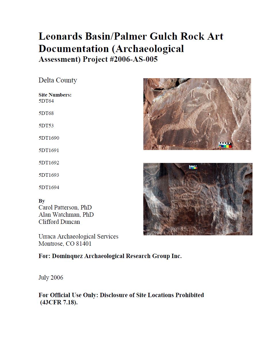
Leonard Basin/Palmer Gulch Rock Art Documentation. Prepared by Carol Patterson, Alan Watchman, and Clifford Duncan, July 2006
Abstract: The rock art sites located in Leonards Basin and Palmer Gulch, Delta County occur in shallow rock shelters and along exposed sandstone cliffs in the Dakota Sandstone. None of the sites in Palmer Gulch have been recorded. Both sites in Leoneards Basin have been recorded but not fully documented. Petroglyphs and charcoal drawings comprise the form of rock art at these sites. They consist of small quadrupeds with horns, mounted riders, bear paws and baskets. Large, wide anthropomorphic figures, spirals, meandering lines and dots make up the unusual and very extensive panel at the end of Palmer Gulch. The sites in Palmer Gulch are significant because they contain relatively old archaic motifs that are part of a larger Uncompahgre Style complex. The main panel at the end of Palmer Gulch had drawn interest from Ute Elder Clifford Duncan who interpreted it as a healing site. The petroglyph symbols and rock incorporation are interactive with the patient as part of a curing ceremony in Ute tradition.
The project report, edited for general release, is available here:
Report of an Archaeological Assessment of the Cultural Resources in Big Dominguez Canyon in Mesa and Delta Counties, Colorado. Prepared by Curtis Martin, Principal Investigator, Nicole Darnell, Rich ott, Carl Conner, and Barbara Davenport for the Bureau of Land Management Grand Junction Field Office
Abstract: The area is known for its high concentration of rock art that is mainly attributable to the Protohistoric/Historic Ute Tribe. The need for this project was due to the increased potential for impacts to these non-renewable resources owing to the construction of a walking bridge across the Gunnison River, which will provide additional access to trails in Big Dominguez Canyon. Accordingly, the goal of this study was to conduct a Class III inventory of a 250-acre area of BLM-GJFO administered lands within the Wagon Park Allotment in order to assess threatened or damaged cultural resources and create a data base from which BLM-GJFO personnel can formulate an areal cultural resource management plan. The project included a review of the records of all known resources in the study area, and an intensive field study to reevaluate the previously identified sites and document sites not formerly recorded.