Archaeoastronomy had a popular revival with the Stonehenge discoveries of the 1960s. In association with the examination of prehistoric and historic Native American cultures, it has since made use of archaeological methods and records to sort out the relationship between functional and symbolic astronomical knowledge, and to identify structures serving as seasonal markers for rituals. Medicine wheels are one of the most commonly known sites in North America. Between 100 and 200 have been identified with the majority being found in the Canadian Provinces of Saskatchewan and Alberta. Fewer have been recorded in North Dakota, Wyoming, Montana, and Colorado. The oldest and largest known, located near Majorville in southern Alberta, was radiocarbon dated about 5000 years before present from an associated bone fragment, and another medicine wheel was dated about 2600 years old. These dates suggest a Middle Archaic origin for the wheels and their geographic distribution appears to match that of the appearance and spread of the Athabascan people in North America.
With the Gunsite Pass and Independence Mountain site assessments, the number of recorded archaeoastronomy sites in North and Middle Parks of Colorado is increased to two. The first to be extensively documented was 5GA4251, the Gunsight Pass site, whose study was primarily funded through State Historical Fund Grant No. 2013-AS-003. Notably, the rock alignments at 5GA4251 are not characterized as medicine wheels. Some are comparable to star charts of the Skidi (Wolf) Pawnee; however, the Pawnee’s stellar maps give no indication of solar observations, and their ceremonial calendar was based on positions of stars, constellations and planets.
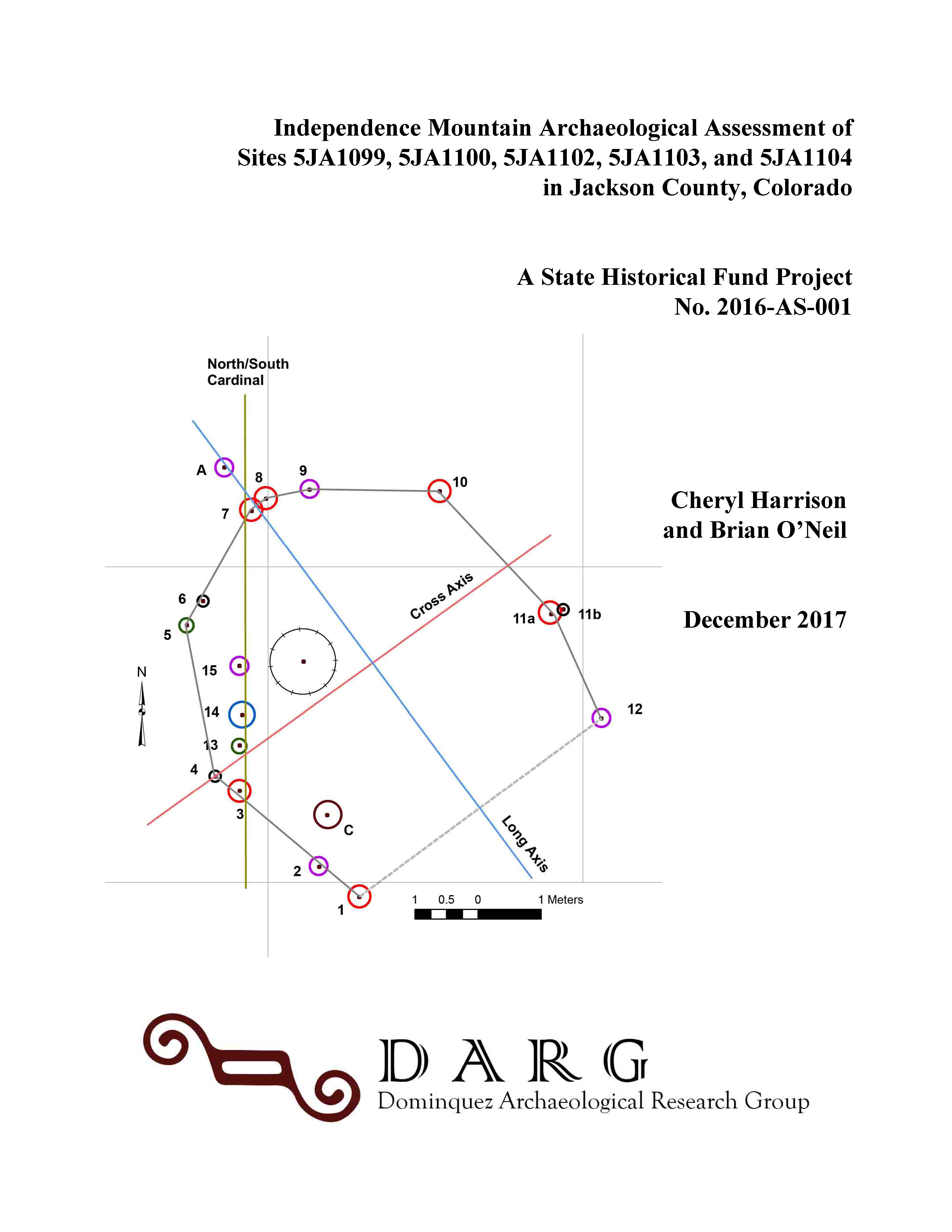
As part of the Independence Mountain project, DARG relocated and mapped the five stone alignment sites predicated in the SHF Archaeological Assessment grant. They consisted of cairns, stone rings, and low walls or combinations of these features along the crest or southern slopes of Independence Mountain. Of the five sites (5JA1099, 5JA1100, 5JA1102, 5JA1103, 5JA1104) only one 5JA1100 showed any potential as a celestial calendar. None of the sites could be considered domestic structures or be referred to as “tipi” rings. The possible relationship between these sites was explored, and only sites 5JA1099 and 5JA1100 may have a relationship as elements of an archaeoastronomy complex.
Accordingly, these sites represent a unique type in the Native American archaeoastronomical record. They also bring into question the documentation of other sites in Colorado that have been categorized as tipi rings. No materials have been obtained or direct associations have been made that can provide a temporal context for these sites, which leaves open the question of their assignment as prehistoric or historic Native American.
Reports and Presentations
Independence Mountain Archaeological Assessment of Sites 5JA1099, 5JA1100, 5JA1103, and 5JA1104 in Jackson County, Colorado for the Colorado State Historical Fund Project No. 2016-AS-001. Prepared by Cheryl Harrison and Brian O'Neil, December 2017
Abstract
Dominquez Archaeological Research Group (DARG) relocated and mapped the five stone alignment sites (5JA1099, 5JA1100, 5JA1102, 5JA1103, and 5JA1104) predicated in the State Historical Fund Archaeological Assessment grant (Project # 2016-AS-001). These sites consisted of stone cairns, stone rings, and low stone walls or combinations of these features along the crest or southern slopes of Independence Mountain in North Park, Colorado. None of the sites are considered domestic structures or should be referred to as “tipi” rings.
Of the five sites only one, 5JA1100, appears to have potential as a celestial calendar (archaeoastronomy site), and has a high probability of being associated with the summer solstice sunrise and sunset. Direct field observations and instrument measurements of the cobble alignment sets, and their associated azimuths from identified observation points need to be made. Such would increase the accuracy of the apparent solar observations and confirm the summer solstice sunrise and sunset skyline positions and the possible use of foreshortened horizons.
The project report, edited for general release, is available here:
An Archaeological Assessment Of The Gunsight Pass Site: 5GA4251 Archaeoastronomy And Landscape Archaeology in Middle Park, Grand County, Colorado. Completed for The Colorado Historical Society. State Historical Fund Project No. 2013-AS-003. Prepared by Brian O'Neil and Cheryl A. Harrison with contributions by Holly Shelton and Nicole Inman. Michael S. Berry as the Principal Investigator, June 2017.
Abstract
The Gunsight Pass Site (5GA4251) is in the Middle Park region of the Southern Rocky Mountains physiographic province, Grand County, Colorado. It is situated atop a prominent north-south trending ridge, southeast of Gunsight Pass, at an average elevation of 8500 feet. The site was first identified in July 2011, as an open architectural and open lithic scatter consisting of multiple surficial and half-buried rock alignments. The purpose of the archaeological assessment was to provide a detailed recording of the stone features and determine whether they represent domiciles or ceremonial features associated with vision quests, or possible astronomical alignments. Additionally, orientations toward potential sacred landscapes such as Whitely Peak, Wolford Mountain, or the Sulphur Gulch area were examined. Another significant goal of the assessment was to provide data on the site for its consideration as a Traditional Cultural Property (TCP) relevant to historic Ute, Arapahoe, and eastern Shoshoni tribes.
The project report, edited for general release, is available here:
Gunsight Pass Site Presentations
Gunsight is a prehistoric stone ring site in Middle Park, Colorado consisting of 30 stone features divided into five localities (A—E). From Medicine Wheels, we inherited: true circles, flattened circles, ellipses/ovals, and egg-shapes, all associated with astronomical observations. At Gunsight we have combinations of shapes: oval, egg, lens, L, J, and irregular polygons. A real mix and match scenario. Is this a reflection of different techniques by different groups and/or at different times, for observation of different celestial bodies or events?