Ute Trails of the Uncomphagre Plateau: Spring Creek and Gunnison Gulch Sections Delta, Mesa, Montrose, and Ouray Counties, Colorado
One of the guiding inquiries for these projects concerned the location and recording of two trails, one in Spring Creek Canyon and one in Gunnison Gulch, that may have been used by Native Americans. DARG conducted an extensive literature review of historic maps, oral histories and memoirs to determine locations of Native American trails and historic pioneer roads of the Southern Uncompahgre Plateau. The following historic maps were consulted: those of F.V. Hayden’s survey of southwestern Colorado between 1874 and 1875, and a survey of western Colorado completed between 1874 and 1876; G. M. Wheeler’s maps of southwestern Colorado between 1875 and 1877; Louis Nell’s topographic map of Colorado from General Land Office surveys and other authentic sources in 1884; the USGS 15 minute quadrangles of Montrose (1909), and Paradox Valley (1916); and, the Uncompahgre National Forest map published by the USDA Forest Service in 1935.
Oral histories relevant to the project area consist of a series of interviews conducted between 1933 and 1934 for the State Historical Society of Colorado by the Civil Works Administration (CWA). As part of that project, the Montrose County series interviews were conducted by Arthur W. Monroe. Memoirs utilized include Uncompahgre, by Muriel Marshall; Trails and Trials, by Eda Baker Musser; I Hauled These Mountains in Here, by Frances Elizabeth Wood and Dorothy Wood; and an article from Colorado Magazine titled Fort Crawford, Colorado, 1880-1890 by Maj. John H. Nankivell.
Poster Gallery - Spring Creek
CLICK ON MAP IMAGE TO OPEN IN NEW WINDOW
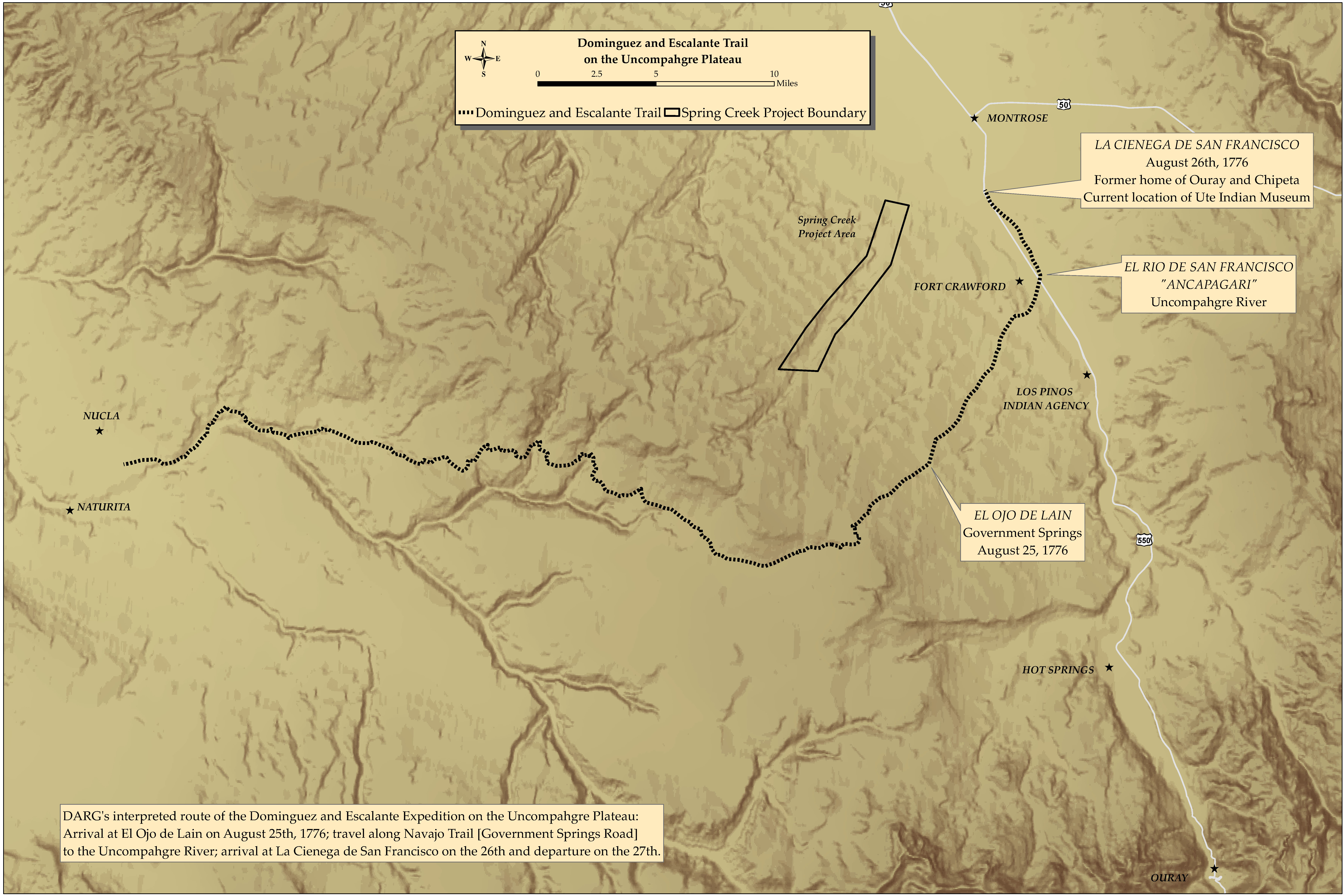
Dominguez & Escalante Trail
DARG's interpreted route of the Dominguez and Escalante Expedition on the Uncompahgre Plateau: Arrival at El Ojo de Lain on August 25, 1776; travel along Navajo Trail [Government Springs Road] to the Uncompahgre River; arrival at La Cienega de San Francisco on the 26th with departure on the 27th.
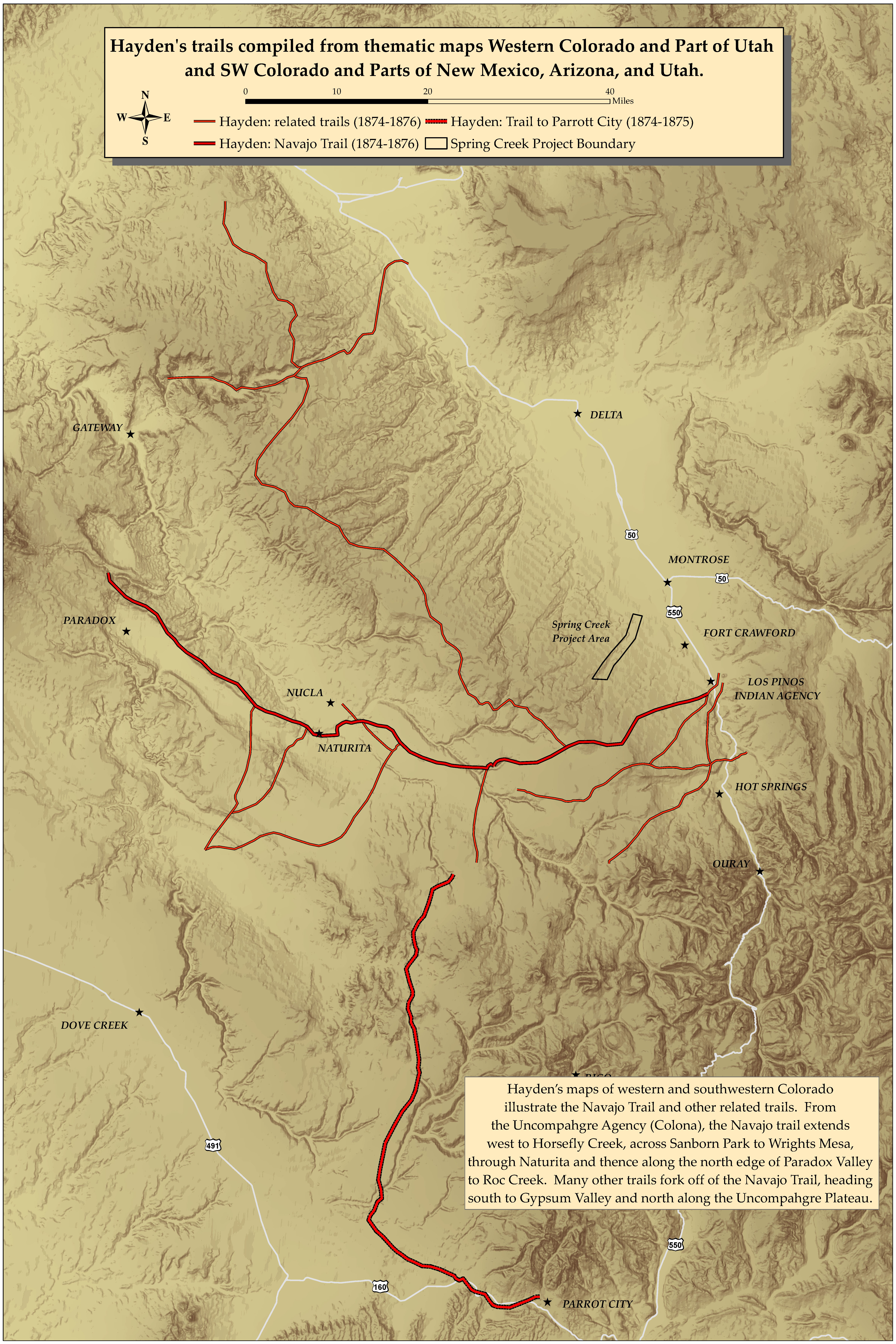
F. V. Hayden, Western Colorado and Part of Utah Southwest Colorado and Parts of New Mexico, Arizona, and Utah
Hayden's maps illustrate the Navajo Trail and other related trails. From the Uncompahgre Agency (now known as Colona), the Navajo trail extends west to Horsefly Creek, across Sanborn Park to Wrights Mesa, through Naturita and thence along the north edge of Paradox Valley to Roc Creek. Many other trails fork off the Navajo Trail, heading south to Gypsum Valley and north along the Uncompahgre Plateau.
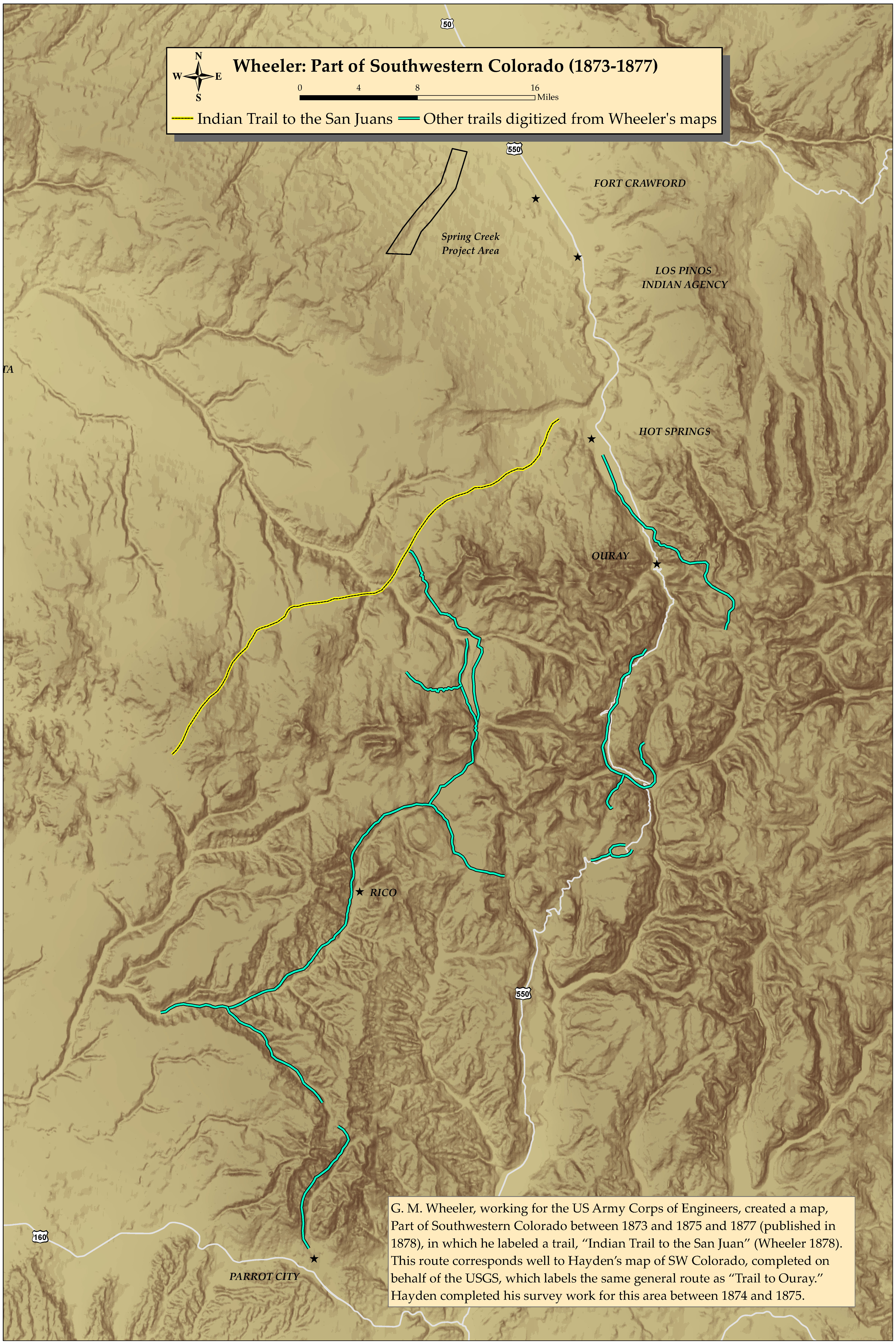
G.M. Wheeler, Part of Southwestern Colorado
G.M. Wheeler, working for the US Army Corps of Engineers, created the map, Part of Southwestern Colorado between 1873 and 1875 and 1877 (published in 1878), in which he labeled a trail, "Indian Trail to the San Juan." This route corresponds well to Hayden's map of SW Colorado, completed on behalf of the USGS, which labels the same general route as "Trail to Ouray." Hayden completed his survey work for this area between 1874 and 1875.
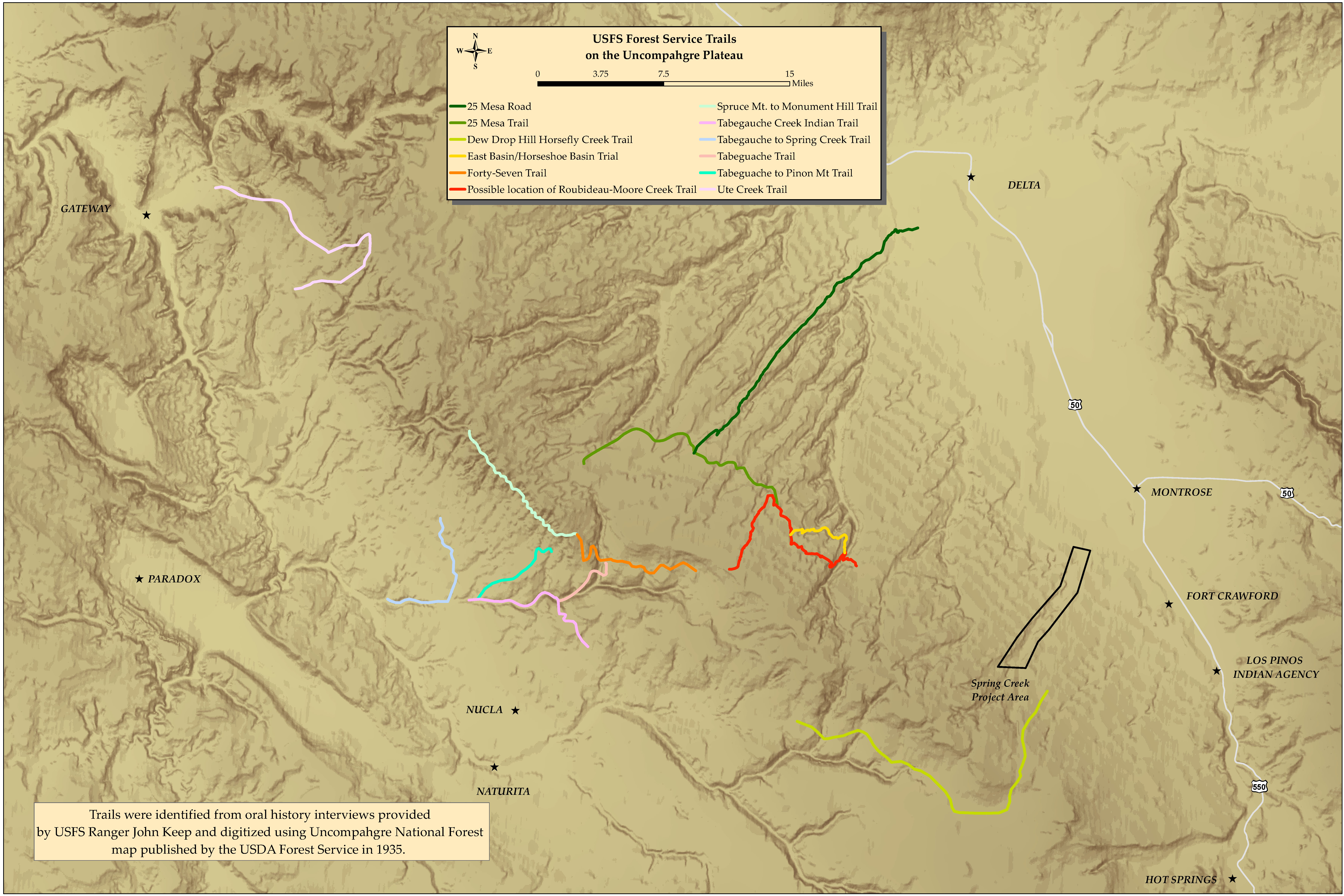
US Forest Service, Uncompahgre National Forest
Trails were identified from oral history interviews provided by USFS Ranger John Keep and digitized using a Uncompahgre National Forest map published by the USDA Forest Service in 1935.
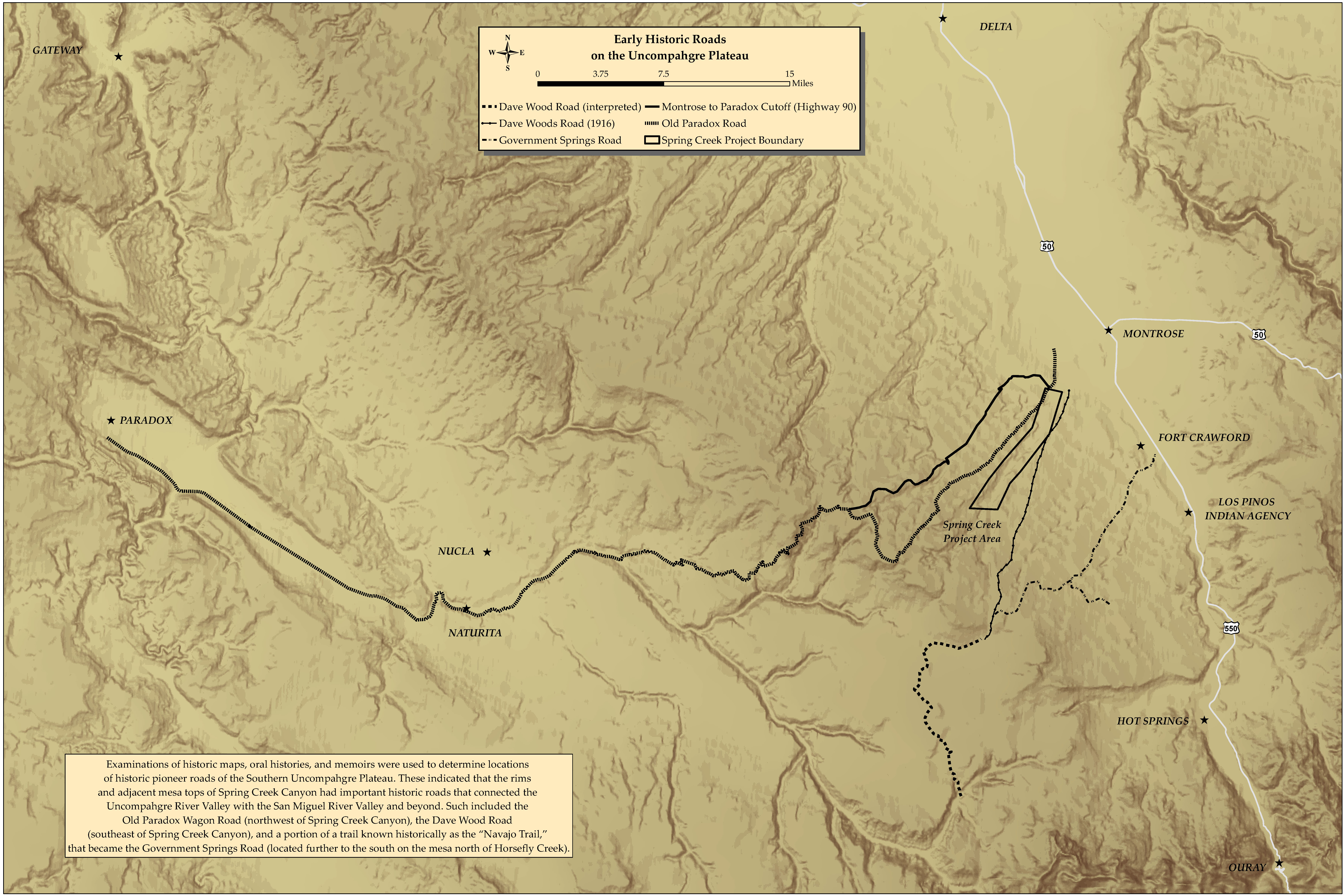
Early Historic Roads
Examinations of historic records were used to determine locations of historic pioneer roads of the Southern Uncompahgre Plateau. These indicated that the rims and adjacent mesa tops of Spring Creek Canyon had important historic roads that connected the Uncompahgre River Valley with the San Miguel River Valley and beyond. Such included the Old Paradox Wagon Road (northwestern of Spring Creek Canyon), the Dave Wood Road (southeast of Spring Creek Canyon), and a portion of a trail known historically as the "Navajo Trail," that became the Government Springs Road (located further to the south on the mesa north of Horsefly Creek)
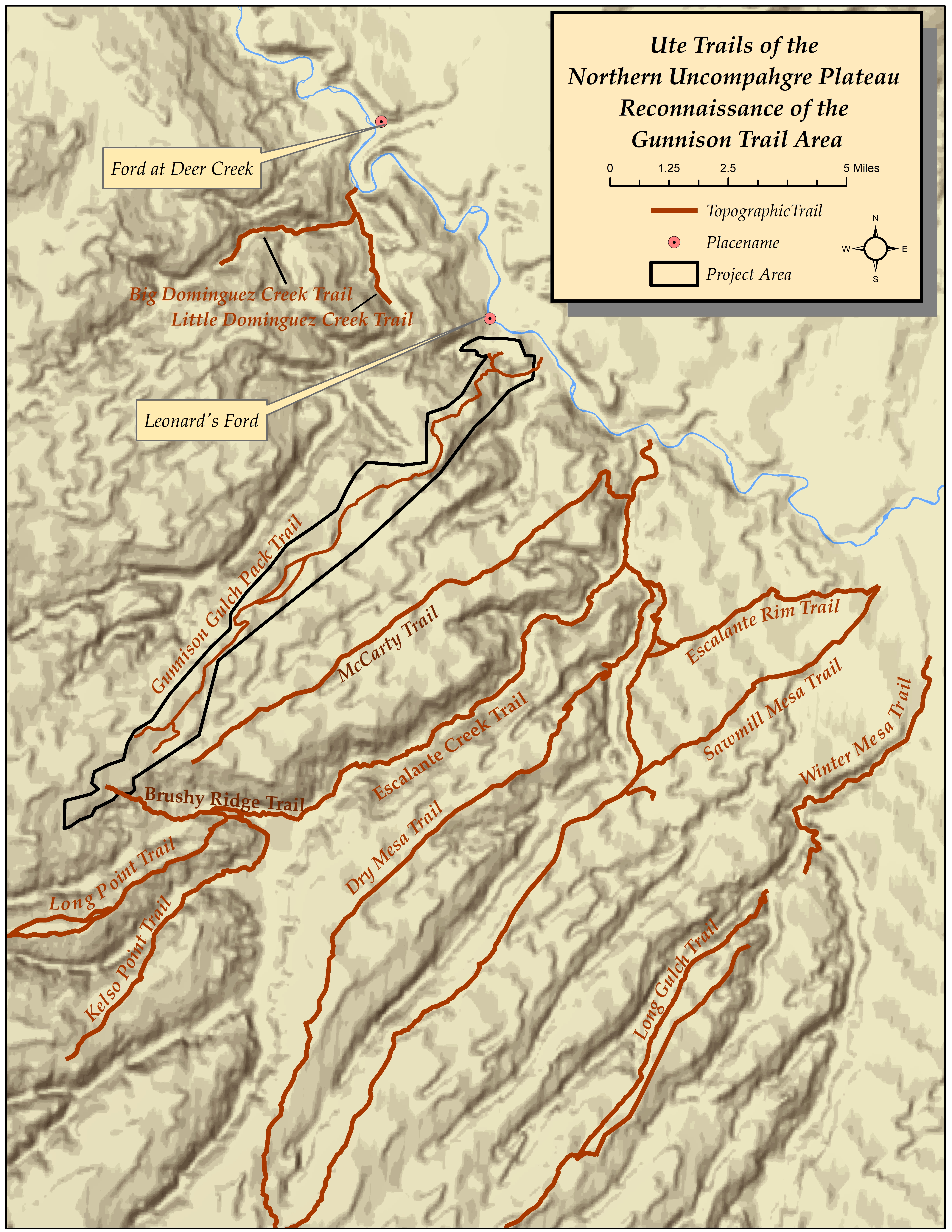
Poster Gallery - Gunnison Gulch
F. V. Hayden, Western Colorado and Part of Utah Southwest Colorado and Parts of New Mexico, Arizona, and Utah
Hayden’s map of western Colorado illustrates the Navajo Trail, as well as many major travel corridors and secondary trails. From the Uncompahgre Agency (Colona), the Navajo trail extends west to Horsefly Creek, across Sanborn Park to Wrights Mesa, through Naturita and thence along the north edge of Paradox Valley into Utah. Many other trails fork off of the Navajo Trail, heading south to Gypsum Valley and north along the Uncompahgre Plateau. This trail crosses the south ends of Monitor Mesa, Sawmill Mesa, Love Mesa, Kelso Mesa, and Long Point. It follows Blue Creek and then turns north, skirting south of Big Dominguez Creek to Unaweep Canyon. These trails extend in both directions in Unaweep Canyon and also continue north to Glade Park. From the Uncompahgre Agency, the Salt Lake Wagon Road travels north where trail spurs fork off to access the West Elk mountain range to the east, and the Grand Mesa to the north.
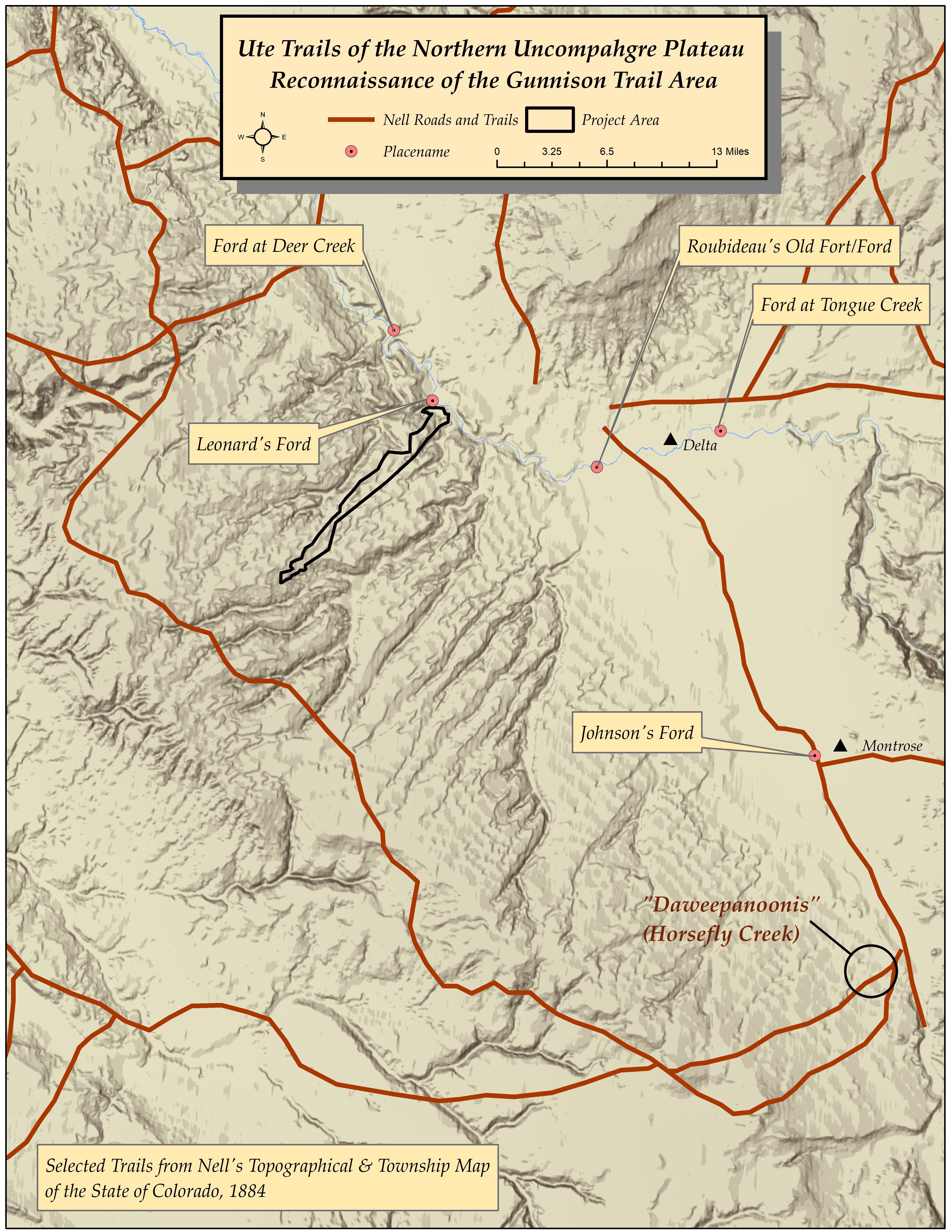
Nell's Topographical & Township Map of the State of Colorado
In 1884, Louis Nell created a pocket map, “Nell’s Topographical & Township Map of the State of Colorado,” which he compiled from US Government Surveys and other authentic sources. It is full color by county. The trails depicted on the Nell map roughly correspond to Hayden’s. Although this map does not indicate “Indian Trails” per se, his map does include what appears to be a reference to a Ute place name, “Daweepanoonis Cr.”; now known as Horsefly Creek.
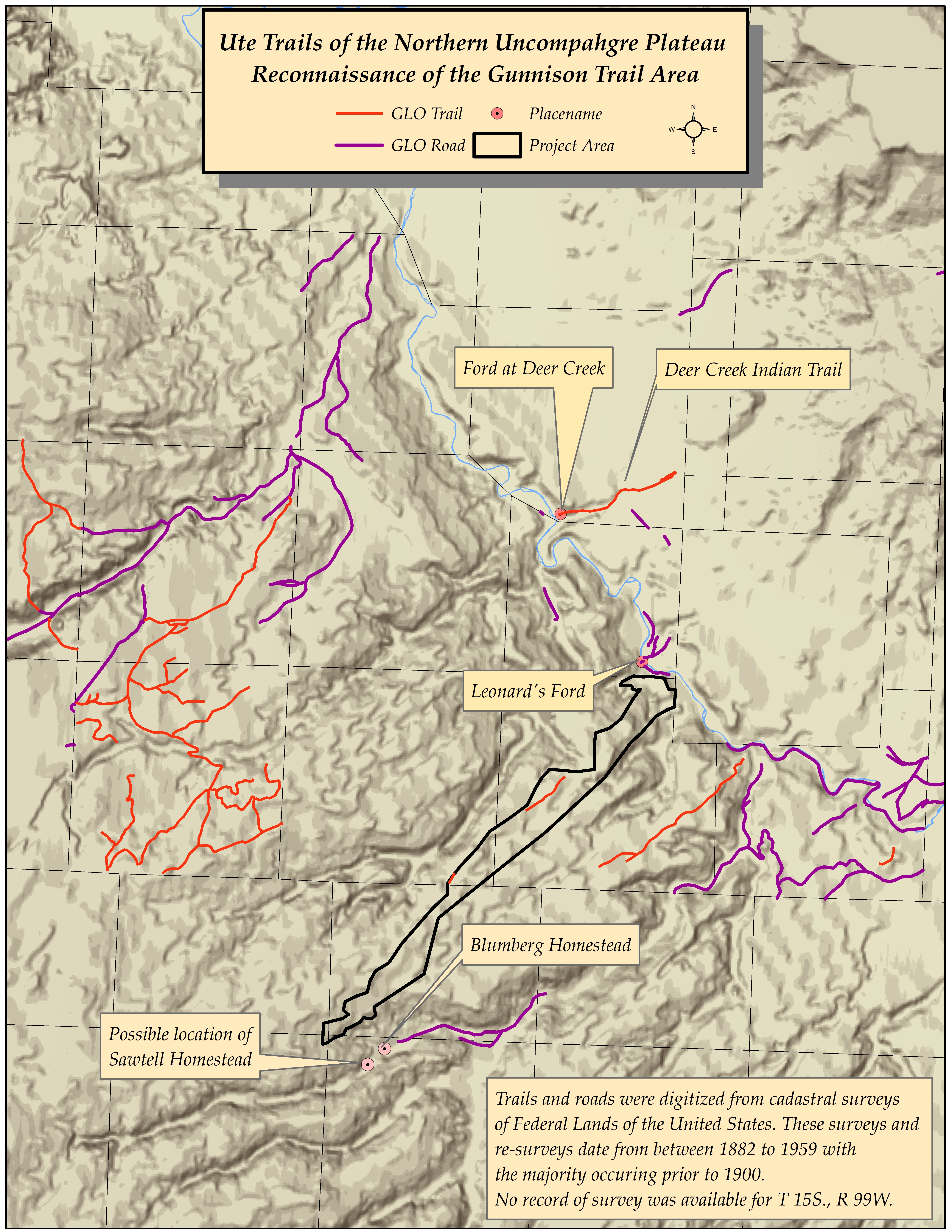
GLO Surveys
Indications of historic trails were searched for on cadastral surveys of Federal Lands. These surveys took place between 1882 to 1959. Only one was identified as an “Indian Trail;” the route from the Ford at Deer Creek northeast towards the Grand Mesa. Others were identified as “Old Trails,” which were likely Native American routes before they were utilized by settlers and cattlemen.
West of Escalante Forks, in T. 50N., R. 14S., Section 5, was the Blumberg Homestead. According to the memoir, Red Hole in Time, the Blumberg’s came to that area in 1881 with R. S. Kelso. He says, “Those first years the Indians used to come through to hunt. They wintered inthe pinyons in wickiups supported by lodge-pole pines they dragged from up around Gunnison. They built better shelters for their dogs–low and warm, lined with cedar bark inside and banked with earth” (Marshall 1988:238). The book then goes on to describe Sawtell, a homestead described as being in the vicinity of the Blumberg’s along the North Bank of the Escalante, established at the same location as a pueblo style village. "Their village spanned the creek from cliff to cliff. Though drifted with sand in the centuries since they left, stone dwellings and underground kivas were visible when our pioneers came, and still may be seen on the far side of the creek, where it was harder for the pioneers to get to them.... When the first settler saw those archaeologically precious remnants, he saw only nice flat rocks that would make a dandy wall for his cellar. The cellar is still intact; the kiva he robbed is a mere depression in the dirt mound above it. The part of the prehistoric ruins that lies across the creek, being out of handy reach, was still there to be scientifically excavated by archaeologists from the Colorado Museum of Natural History fifty years ago" (ibid:243-244).
Topographic Maps
Several topographic trails were also digitized for this project. According to the memoirs Trails and Trials, a Ute trail led onto Kelso Point from the head of Kelso Creek and a well-defined Ute trail ran across Long Point in the headwaters of Escalante Creek (1986). These are located south of the Brushy Ridge Trail and provided good access to the confluence at Escalante Forks.