Trails are historically significant to today's living descendants of the Utes that traveled them, and to the diverse professional and public communities that value and study Ute heritage and early western Colorado history. Trails systems were important corridors linking primary river crossings and seasonal destination locales. DARG has opted to examine trail systems because, empirically speaking, these trails appear to tie together subsistence resources, activity loci, camp sites, and rock art panels. As well, trails were used by individuals and groups to come together for ceremonial purposes (a reaffirmation of human relationships such as the Bear Dance) or to move along a particular trail as part of a spiritual pathway by revisiting sacred sites (particular landscape localities or rock art sites). Essentially, they were the links between individuals and groups to their past, their mythology of the landscape, and the land itself.
Many of the Ute trails are indicated on early maps and described in ethnohistories of the region (Preuss 1848; Hayden 1881). These were undoubtedly key routes that connected Utes living in west-central Colorado with not only a variety of seasonally-productive procurement areas but also other Ute bands. A number of studies in recent years, have begun to reveal the breadth of the ancestral landscapes that provided material and spiritual sustenance to the Utes across a sweep of time reaching from prehistory to little more than one hundred-twenty years ago. It has become clear that the traditional cultural heritage of the Utes lies not only in their archaeological legacy, but in the aboriginal trails and natural landscapes of their ancestral homelands. These conjoined systems constitute cultural landscapes that were, and continue to be, significant in the world view of the Numic speaking groups of western Colorado.
Recent Research
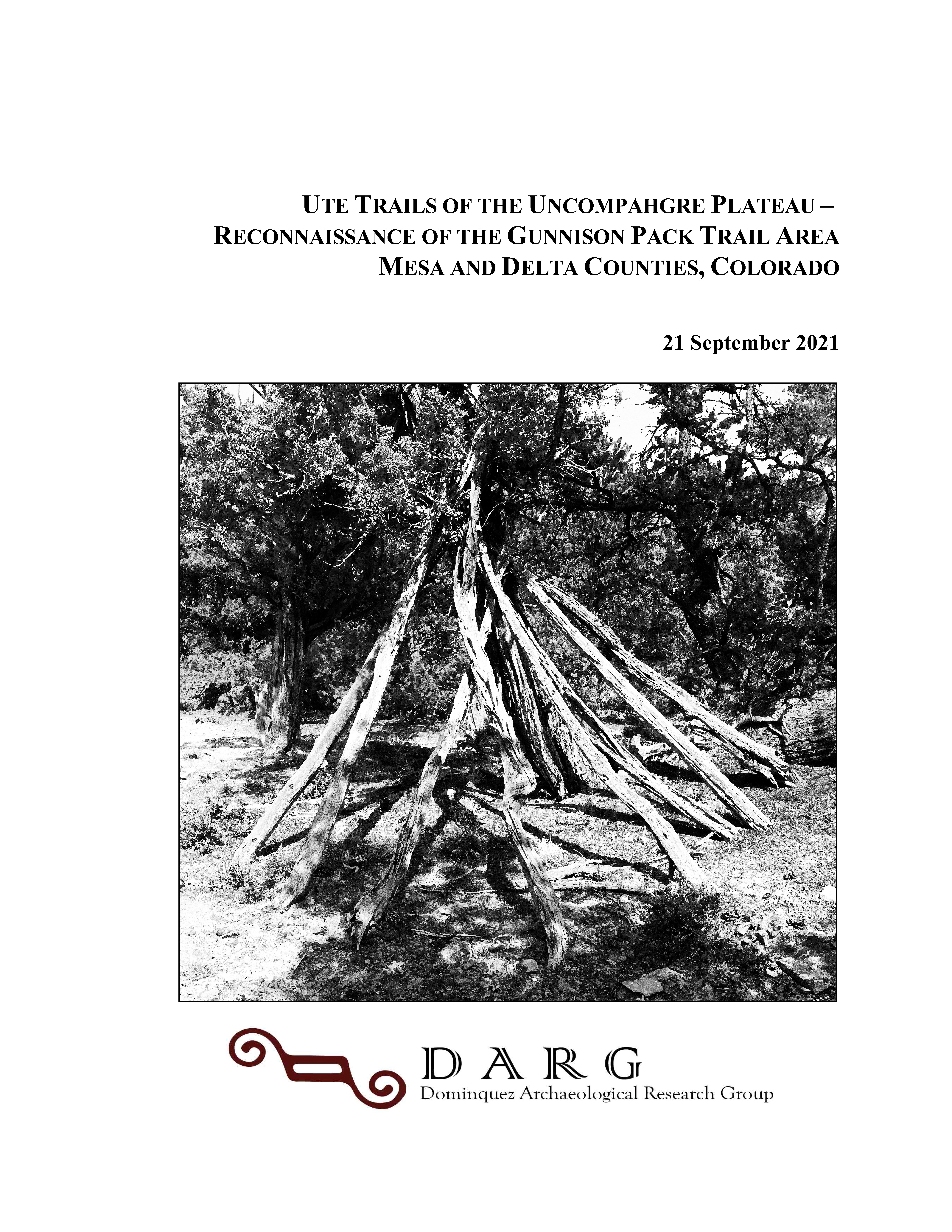
Ute Trails of the Uncomphagre Plateau: Reconnaissance of the Gunnison Pack Trail Area in Mesa and Delta Counties, Colorado. Prepared by Carl E. Conner, Principal Investigator, Barbara Davenport, Nicole Inman, Rich Ott, Julie Coleman, Mike Berry, Courtney Groff and Natalie Higginson for History Colorado State Historical Fund, September 2021.
Abstract: This project examined the prehistoric and historic cultural landscape associated with the Gunnison Gulch Pack Trail by conducting a reconnaissance survey that included site-revisits containing Ute conical lodges. This information will be used in research goals that emphasize the identification and interpretation of regional patterns in prehistoric chronology, settlement, mobility, trade, resource use and technology. Known historic trails are discussed as primary accesses between the lower and upper elevations of the Uncompahgre Plateau and as connections between the river drainages. A digital recording of trails or sections of trails across the eastern side of the Plateau was expanded through a search of GLO maps, other historic maps, and written and oral histories. An ARCGIS file of that work will be shared with History Colorado, the Forest Service, Bureau of Land Management, and Tribal Cultural Offices to be used in the future identification of trails and to determine their associations with cultural resource sites.
Utilization of the Gunnison Gulch Pack Trail by Utes as one of the main trails to the higher elevations was examined through recording the spatial patterning of the material remains from their historic activity in relation to environmental settings. Conical lodges and their locations on the landscape of Colorado contribute to an understanding of the history of the Ute people during the period from AD 1640 to the early 1900s. They are a National Heritage that is being lost to time.
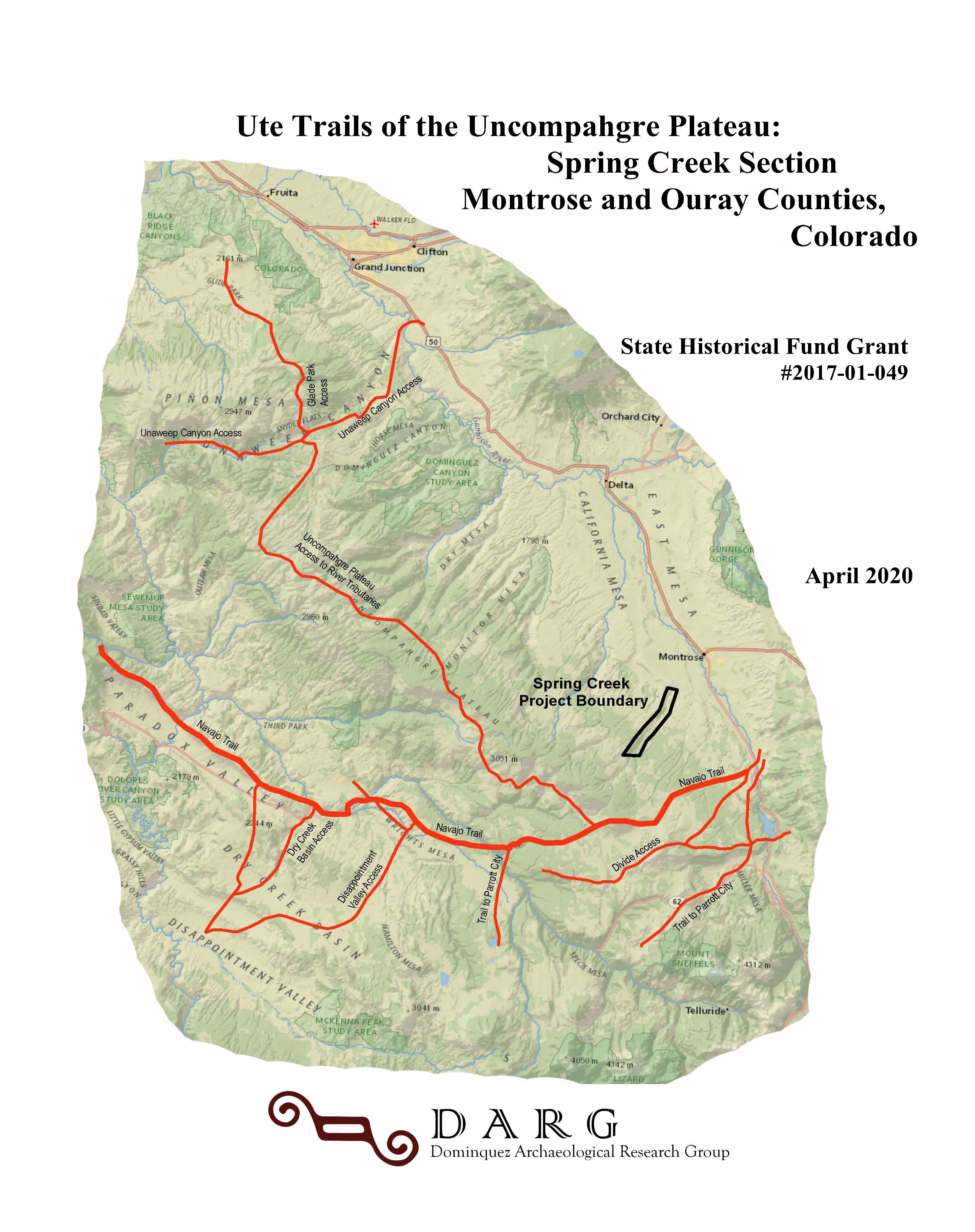
Ute Trails of the Uncompahgre Plateau: Spring Creek a Gunnison Gulch
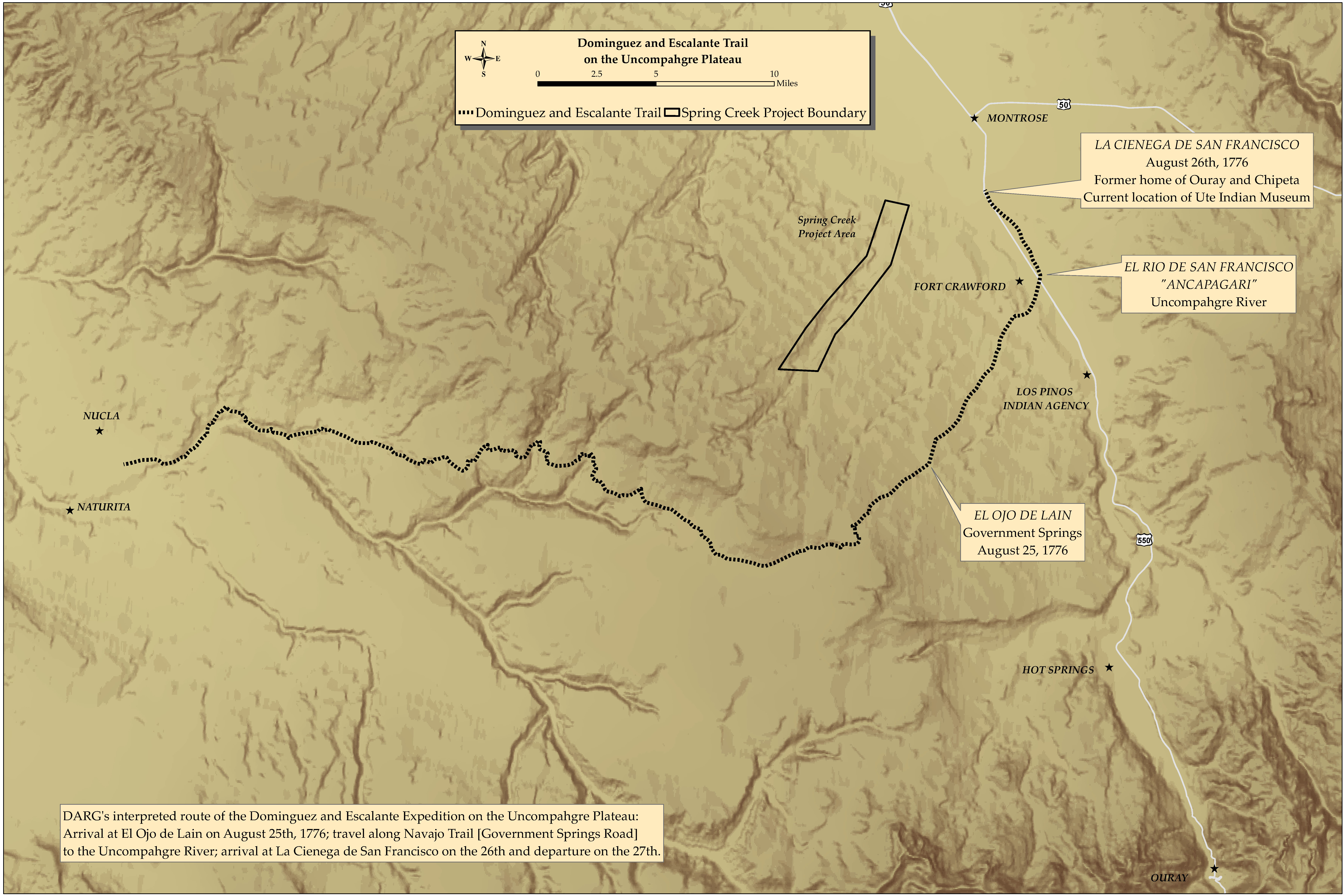
Ute Trails of the Uncomphagre Plateau: Spring Creek Section in Montrose and Ouray Counties, Colorado. Prepared by Carl E. Conner, Principal Investigator, Barbara Davenport, Nicole Inman, Rich Ott, Julie Coleman, Mike Berry, Courtney Groff and Natalie Higginson for History Colorado State Historical Fund Project No. 2017-01-049, April 2020.
Abstract: This project examined the prehistoric and historic cultural landscape associated with Spring Creek Canyon by compiling baseline data from archaeological, ethnographic and ethnohistorical records of the eastern slope of the Uncompahgre Plateau, examining curated artifact collections, and conducting a reconnaissance survey that included site-revisits and new recordings. This information is being used in research goals that emphasize the identification and interpretation of regional patterns in prehistoric chronology and settlement, mobility and trade, and resource use and technology. Known historic trails that border Spring Creek Canyon are discussed as primary accesses between the lower and upper elevations of the Uncompahgre Plateau and as connections between the river drainages. A search of GLO maps, other historic maps, written and oral histories extended the digital recording of trails or sections of trails across the southern and eastern side of the Plateau. An ARCGIS file of that work will be shared with not only History Colorado, but also the Forest Service and Bureau of Land Management offices and the Tribal Historic Preservation Officer, to be used in the future identification of trails and to determine their associations with cultural resource sites.
Utilization of the Spring Canyon bottom by Native Americans as one of the main trails to the higher elevations was examined through recording the spatial patterning of the material remains from prehistoric activity in relation to their topographic and other environmental settings. An assessment of previous work in a broader portion of the Uncompahgre Plateau area was undertaken to determine site density and distribution, and previously assigned cultural affiliation. As well, a database of cultural resources located on the eastern portion of the Uncompahgre Plateau was created to better understand those attributes in a format that can be utilized by federal land management agencies and Ute Tribes to protect and preserve them. A reassessment of standardized site types was undertaken that resulted in the employment of more specific attributes to better define a site’s purpose in landscape utilization. By so doing, the report proffers a contribution to the scientific understanding of the region and in the formulation of new strategies for future archaeological investigations.
Seventeen radiocarbon samples were secured and dated from thirteen sites within and near the study area and compared to data from the region. This was done in an effort to further define the temporal distribution of the sites along the east slope of the Uncompahgre Plateau. Sites exhibiting single components (or few components), and preferably containing diagnostic projectile points, were selected. Dates ranged from the Middle Archaic through Historic Numic occupations, with three distinct clusters that occur during the early Formative (or Late Archaic) ca. 200 BC to AD 300; the Middle Formative, ca. 600-1000 AD; and, the Early Numic period, ca. AD 250-1640. The results of the radiocarbon data was added to the RC database created by Michael Berry.
The project report, edited for general release, is available here:
Poster Gallery - Spring Creek and Gunnison Gulch
The poster gallery presents a number of maps showing digitized trail systems based on a number of archival sources. Click the link below to view the gallery.
Presentations
Our search for Native American Trails began with recorded historic trails of the Spring Creek Canyon area located southwest of Montrose. Examinations of General Land Office (GLO) and other maps*, oral histories and memoirs were used to determine locations of Native American trails and historic pioneer roads of the Southern Uncompahgre Plateau. These indicated that the rims and adjacent mesa tops of Spring Creek Canyon had important historic roads that connected the Uncompahgre River Valley with the San Miguel River Valley and beyond. Such included the Old Paradox Wagon Road (northwest of Spring Creek Canyon), the Dave Wood Road (southeast of Spring Creek Canyon), and a portion of a trail known historically as the “Navajo Trail,” that became the Government Springs Road (located further to the south on the mesa north of Horsefly Creek).
This project examined the prehistoric and historic cultural landscape associated with Spring Creek Canyon by compiling baseline data from archaeological, ethnographic and ethnohistorical records of the eastern slope of the Uncompahgre Plateau, examining curated artifact collections, and conducting a reconnaissance survey that included site revisits and new recordings. This information is being used in research goals that emphasize the identification and interpretation of regional patterns in prehistoric chronology and settlement, mobility and trade, and resource use and technology.
Related Research and Reports
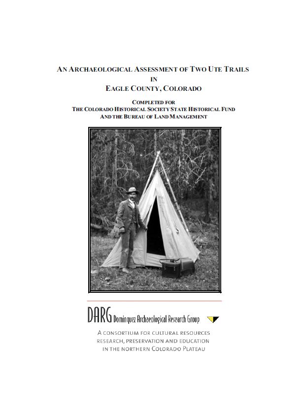
Archaeological Assessment of Two Ute Trails in Eagle County, Colorado. Prepared by Carl E. Conner (Principal Investigator), Curtis Martin, Richard Ott, and Holly Shelton for the History Colorado State Historical Fund (Project No. 2015-02-024) and the Bureau of Land Management Colorado River Valley Field Office. February 2016
Abstract: Dominquez Archaeological Research Group (DARG), by means of a cultural resources research grant from History Colorado State Historical Fund (SHF Project #2015-02-024) and under a Bureau of Land Management Colorado River Valley Field Office (BLM) field authorization, conducted a study entitled Ute Trails of Eagle County that included segments of two aboriginal trail systems within the Colorado River corridor. Centrally located in the Northern Utes' aboriginal territory, the two selected trail segments are part of the Sawatch Mountains system (Pisgah Mountain Section, ~9.0 miles) and White River Plateau system (Dotsero Section, ~2.75 miles). These segments offer rich and varied sources of archaeological information, and are historically significant to today's living descendants of the Utes that traveled them.
A total of 2500 acres in two discrete parcels and centered on two suspected Ute Trails was included in the reconnaissance survey for cultural resources. Participants in the inventory of the Pisgah Mountain Section included PAAC members and members of the History Colorado SHF staff. Overall 33 sites and 71 isolated finds were identified with the present study.
The project report, edited for general release, is available here:
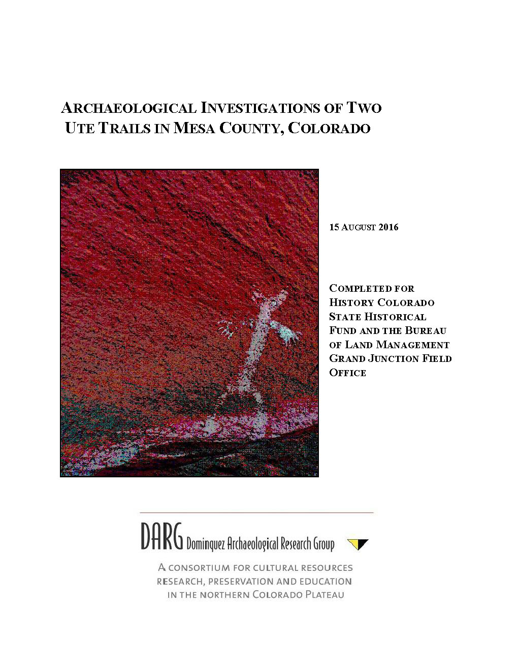
Archaeological Investigations of Two Ute Trails in Mesa County, Colorado. Prepared by Carl Conner (Principal Investigator), Michael S. Berry, Sally J. Cole, Curtis Martin, Richard Ott, Nicole Darnell, Courtney Groff, and Hannah Mills for the History Colorado State Historical Fund (Project No. 2014-01-054) and the Bureau of Land Management Grand Junction Field Office, August 2016
Abstract: Dominquez Archaeological Research Group (DARG) pursued this project, entitled Ute Trails of Mesa County, for the purpose of conducting a landscape-scale, multi-disciplinary study of two sections of the historic/prehistoric Ute Trails in Mesa County Colorado. This research project was funded by cultural resource grants from History Colorado State Historical Fund (SHF Project #2015-02-024), the Bureau of Land Management Grand Junction Field Office (BLM) , and Grand River Institute. This project was conducted under Section 110 of the National Historic Preservation Act (NHPA, 16 U.S.C. § 360), and authorized by BLM Permit No. C-67009.
This study integrates archaeological, ethnohistoric and contemporary Native American perspectives. The purposes of the study were to conduct database work, fieldwork school, Ute consultation, rock art documentation, field survey of sites, analysis and completion of the final report and public outreach and information sharing. This included the identification of suspected prehistoric and historic trails or travel routes, the investigation and recording of the general distribution of associated cultural resources, and the evaluation of the significance of the cultural resources for inclusion on the National Register of Historic Places (NRHP).
Two potential aboriginal trails were selected for the project. Located in the Northern Utes’ aboriginal territory, both trails were important corridors linking key river crossings and seasonal destination locales for aboriginal inhabitants in west-central Colorado as evidenced by the clustering of Early Numic, Historic Ute and other archaeological sites that have been recorded in the selected study areas. The nature of this study encompassed revisiting and reevaluating 34 selected sites and the recording of 15 sites and 84 isolates that were newly discovered within 20 (randomly selected) 20-acre inventory blocks. Thus, a total of 400 acres of BLM land was newly inventoried and 133 resources were addressed.
Information about the recorded sites was included in a database for the Ute Trails of Colorado and is augmented by a map-based findings review – both of which are accessed through the DARG website under password. Ute tribal participation has occurred at the development and findings stages. Additional involvement is expected during official consultation and specific site visitations that will be co-sponsored by BLM.
The project report, edited for general release, is available here:
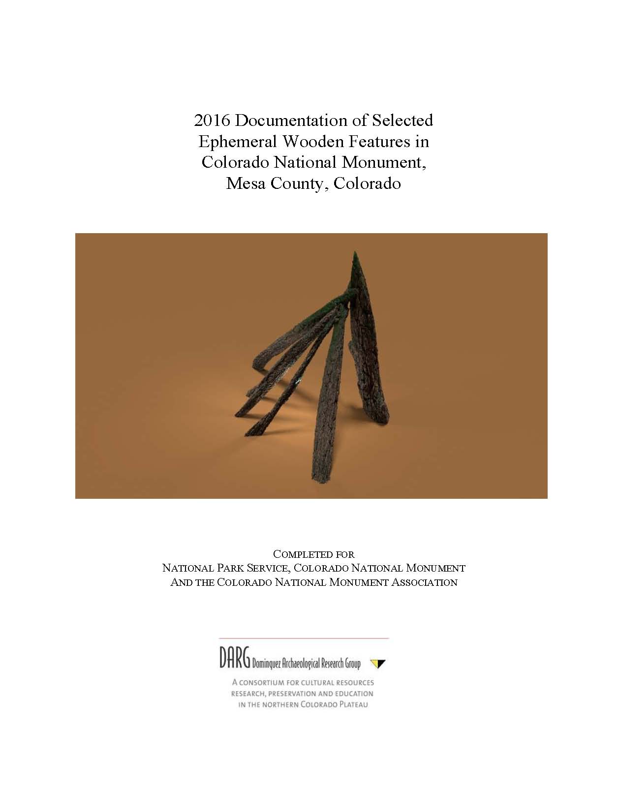
Documentation of Selected Ephemeral Wooden Features in Colorado National Monument, Mesa County, Colorado Prepared for National Park Service, Colorado National Monument and the Colorado National Monument Association. Prepared by Carl Conner, Masha Conner, Barbara Davenport, and Nicole Inman in association with the Ute Trails of Colorado Project, November 2016.
Abstract: At the request of Colorado National Monument archaeologist Matthew Marques, Dominquez Archaeological Research Group, Inc. conducted supplemental documentation of previously recorded wooden features found at four sites in the Colorado National Monument. These structures are located in sites: 5ME60, 5ME13174, 5ME20741 and 5ME20779. Field work consisted of a review of the sites’ attributes, detailed mapping of the wooden structural features, and photographing those features with a high quality digital camera. For two of the revisited sites where conical features were recorded (5ME60 and 5ME20741), 3D reconstructions were made of the collapsed wooden features.
The project report, edited for general release, is available here:
Ute Trails Project: Phase I Years 2010-2012 Reconnaissance Survey of Ute Trails on the Uncompahgre Plateau in Mesa County, Colorado for History Colorado State Historical Fund and the Bureau of Land Management Grand Junction Field Office. Prepared by Carl Conner, Principal Investigator, Michael S. Berry, Sally J. Cole, Curtis Martin, Richard Ott, Nicole Darnell, Courtney Groff, and Hannah Mills, 2013
Abstract: This study integrates archaeological, ethnohistoric and contemporary Native American perspectives. The purposes of the study were to conduct database work, fieldwork school, Ute consultation, rock art documentation, field survey of sites, analysis and completion of the final report and public outreach and information sharing. This included the identification of suspected prehistoric and historic trails or travel routes, the investigation and recording of the general distribution of associated cultural resources, and the evaluation of the significance of the cultural resources for inclusion on the National Register of Historic Places (NRHP).
Two potential aboriginal trails were selected for the project. Located in the Northern Utes’ aboriginal territory, both trails were important corridors linking key river crossings and seasonal destination locales for aboriginal inhabitants in west-central Colorado as evidenced by the clustering of Early Numic, Historic Ute and other archaeological sites that have been recorded in the selected study areas. As a result, two trail segments (5ME14289.2 and 5ME19750.1) and 20 associated cultural resources were newly recorded. Importantly, this reconnaissance survey served to provide a foundation for future Class III cultural resource inventories to further investigate the omnipotence and significance of prehistoric and historic trail systems.